Long-term
monitoring of vegetation dynamics on St. George
Island, FL
Since
1992, the Miller Lab has been working on various
aspects of the vegetation on the eastern tip of St.
George Island, Florida. St. George is a typical
microtidal barrier island located on the Gulf Coast of
the Florida panhandle. Its 48 km length and narrow
width (0.5 to 2 km) are sculpted by a low tidal range
and frequent overwash by storms. Habitat zones are
determined by the island's characteristic topography,
with a high fronting line of foredunes on the ocean
side, behind which there is an overwash interdune,
with older, more stable backdunes on the bayside. This
dune structure is common to many barrier islands
worldwide and is thought to be due, in part, to
interactions with vegetation. Dunes and troughs create
a heterogeneous habitat for a variety of plants, while
the plants act to stabilize the geomorphology.
We
originally worked on the effects of competition and
herbivory on Sebatia stellaris and on local
adaptation in Hydrocotyle bonariensis
(Knight and Miller 2004). However, from the very
beginning we were struck by how much the dune
vegetation was a shifting mosaic of different species.
From year to year, the identities and locations of the
plants changed, sometimes dramatically. Although
hurricanes were an obvious factor determining plant
community patterns, it also appeared that there was
significant variation in hurricane sensitivity among
plant species, as well as perhaps other factors at
play.
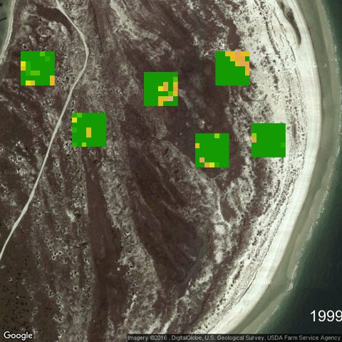
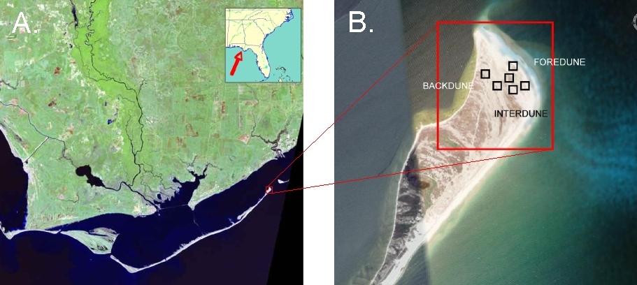 To
better understand these patterns, we established at
set of six 60 m x 60 m plots on the eastern tip of the
island in 1998. Two plots were established each in the
high but unstable front dunes, the wet and lower-lying
interdunal areas, and the more stable rolling back
dunes (this has since been expanded to nine plots,
with three in each habitat). Within each plot, we set
up permanent markers every 10 m in a 7 x 7 grid. We
have sampled a 1 m squared plot at each of the 294
grid points since 1998 (Figure 1). These plots have
been expanded to 3 replicates in each habitat in 2010,
with 441 plots overall.
To
better understand these patterns, we established at
set of six 60 m x 60 m plots on the eastern tip of the
island in 1998. Two plots were established each in the
high but unstable front dunes, the wet and lower-lying
interdunal areas, and the more stable rolling back
dunes (this has since been expanded to nine plots,
with three in each habitat). Within each plot, we set
up permanent markers every 10 m in a 7 x 7 grid. We
have sampled a 1 m squared plot at each of the 294
grid points since 1998 (Figure 1). These plots have
been expanded to 3 replicates in each habitat in 2010,
with 441 plots overall.
Some
dynamics are apparent already (see Miller et al.
2010). For example, Heterotheca subaxillaris
and Oenothera humifusa are intolerant of
saltwater inundation. Such species spread widely
across the dunes between storms (such periods may last
several years), only to be dramatically restricted to
the highest dune areas or even totally eliminated
following high storm surge. Other species such as Uniola
paniculata and Schizachyrium
maritimum are relatively robust and may be
particularly important for dune recovery following
hurricanes and other major storms (Gornish and Miller
2010, 2013).
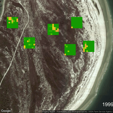
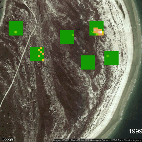
Patterns of vegetation change from 1999 to 2015 in
animations:
Click
on the links below to watch how populations of each
species change through time
Coastal
Vegetation Patterns and the Deepwater Horizon
Oil Spill
In
2010, the Deepwater Horizon (DWH) oil spill
occurred, which has significantly affected our
research program. The details of the initial DWH
incident are well known: a deepwater offshore
oil-drilling rig exploded on 20 April 2010 at the
Macondo Prospect off the coast of Louisiana. An
estimated 4.9 million barrels of crude oil were
released by the resulting sea-floor oil gusher until
it was capped on July 15, 2010. Although the fate of
much of the oil remains unknown, by 9 July 2011 some
790 kilometers of coastline in the northern NGM were
contaminated by DWH oil, including much of the
Louisiana, Mississippi, and Alabama coastlines, and
the western panhandle in Florida (Fig. 2).
 We
realized that we had one of the very few long-term
data sets for coastal vegetation in the Gulf of
Mexico. Further, our data suggest that species are
highly variable in these habitats, so that
separating out any possible signals of oil on
coastal vegetation may be difficult, given the
noise created by normal stochastic forces. In such
cases, long-term data are invaluable to distinguish
if oil does or does not have any affects on the
vegetation of barrier islands.
We
realized that we had one of the very few long-term
data sets for coastal vegetation in the Gulf of
Mexico. Further, our data suggest that species are
highly variable in these habitats, so that
separating out any possible signals of oil on
coastal vegetation may be difficult, given the
noise created by normal stochastic forces. In such
cases, long-term data are invaluable to distinguish
if oil does or does not have any affects on the
vegetation of barrier islands.
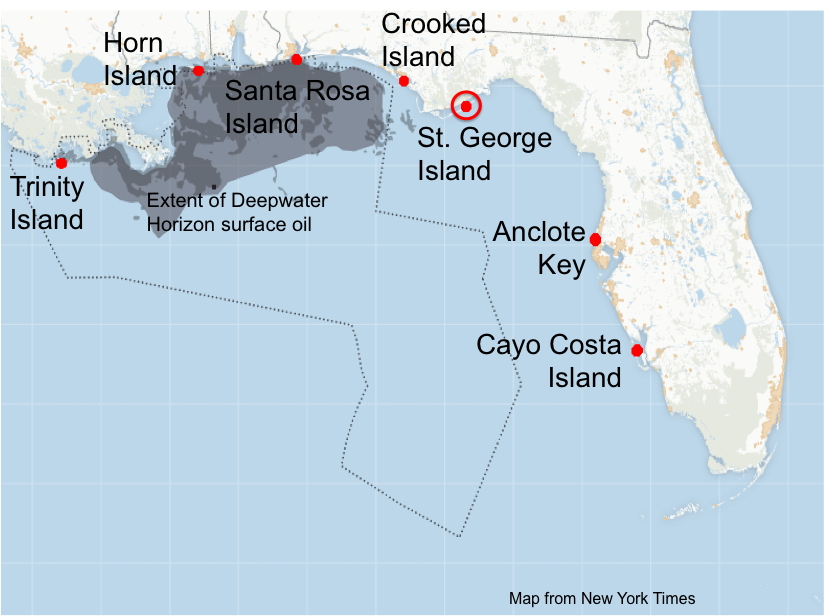
So we initiated a new census at six more barrier
islands sites, scattered somewhat regularly around
the northern Gulf of Mexico, with the intent to
place the sites over a gradient of oil exposure
(Fig. 2). With support from the National Science
Foundationand the Northern Gulf Institute, we have
now initiated six additional long-term sites on
barrier islands spread across the northern Gulf of
Mexico. These sites are approximately 160 km apart
along a gradient of oil exposure and include Trinity
Island (LA), Horn Island (MS), Santa Rosa Island
(FL), East Crooked Island (FL), Anclote Key (FL),and
Cayo Costa (FL), all censused using the methods
developed for the on-going census on St. George
Island, FL.
We have now censused most of these sites for 2010
and 2014; the data are publicly available through
these pages (see below).
All
questions about this research or about the data
should be addressed to T. Miller, Dept. of
Biological Sciences, Florida State University,
Tallahassee, FL 32306, 850-644-9823 or miller@bio.fsu.edu.
Methods
Species
List
Census
Data
Publications